


Lozère j1

rigol05
User

Length
25 km

Max alt
1420 m

Uphill gradient
750 m
Km-Effort
36 km

Min alt
569 m

Downhill gradient
1066 m
Boucle
No
Creation date :
2015-07-05 00:00:00.0
Updated on :
2015-07-05 00:00:00.0
7h16
Difficulty : Medium

FREE GPS app for hiking
 SityTrail
IGN / Geographical institutes
SityTrail Plus
The world is yours!
About
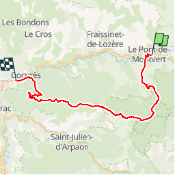
Trail Walking of 25 km to be discovered at Occitania, Lozère, Pont de Montvert - Sud Mont Lozère. This trail is proposed by rigol05.
Description
Etape du Pont de Montvert à Bédouès 24km - Itinéraire très beau sur 12 km jusqu'au col du Sapet.La suite du parcours est exclusivement sur piste forestière et présente peu d'intérêt.
Positioning
Country:
France
Region :
Occitania
Department/Province :
Lozère
Municipality :
Pont de Montvert - Sud Mont Lozère
Location:
Le Pont-de-Montvert
Start:(Dec)
Start:(UTM)
559548 ; 4912392 (31T) N.
Comments